Tributaries and drainage of Lake Baikal. Angara River
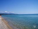
Lake Baikal differs from many other bodies of water not only in its extraordinary depth, but also in the incredible purity and transparency of the water. It owes its great depth to the fact that it is located in a crevice of tectonic origin. Many rivers flow into the lake, but only one river carries Baikal water with it. Quite often there is confusion about which rivers flow into Baikal and how many there are in total. But, as it turned out, these rivers were counted together with streams, and sometimes without them. Some of the small watercourses may periodically disappear due to weather conditions. It is now believed that about one and a half hundred of these streams could have disappeared altogether due to the anthropogenic factor.
According to official data, Baikal now has 336 watercourses, one of which, and a very large one, is the river flowing from Baikal - the Angara. Among the tributaries are such large rivers as the Selenga, Turka, Barguzin and Snezhnaya. Among the large tributaries of the lake there is also a river, which with its name brings another confusion - this is the Upper Angara. Many people confuse it with the Angara, and therefore the latter is considered a tributary instead of a drainage. The smaller rivers of Baikal sometimes have very funny names: Cheryomukhovaya, Golaya, Kotochik, Durnya. The latter, however, flows not into the lake itself, but into the Kotochik River, which, in turn, flows into Turku, and it already flows into Baikal. Nevertheless, the fact that the Fool carries its waters into the “Glorious Sea” remains an irrefutable fact. And there are over a thousand such rivulets and streams! Therefore, if you walk around the entire basin, it will be difficult to count how many rivers flow into Baikal in total. Therefore, we will describe the largest rivers of Baikal.

Angara's naughty daughter
Falling from the heights, the river flowing from Lake Baikal - the Angara - runs away. At its source there is the Shaman Stone rock. Legend has it that Father Baikal threw this stone after his runaway daughter. Love for the hero Yenisei prompted her to escape, but her father predicted another hero, whose name was Irkut, as her groom. In fact, such a powerful flow is only beneficial for Baikal. The aforementioned streams flowing into the lake bring unpolluted water, making their way through forest thickets, located far from large industries and highways.
Baikal has another secret of cleanliness - its plankton, teeming with epishura crustaceans, which process organic matter. The work of these microscopic creatures is comparable to the action of a distiller. This is where the unprecedented transparency of the water comes from, in which there are very few dissolved salts.
The hangar is clean and beautiful river with transparent and clean water. Its length is 1779 km. The wide species composition of the ichthyofauna makes the Angara a very attractive object for recreational fishing. There are more than 30 species of fish in the river.
Large tributaries of the Angara:
- Taseeva;
- Ilim;
- Chadobet;
- Kamenka;
- Kata and others.
Now it’s time to talk about which rivers flow into Baikal. The largest of them is Selenga. This river flows through the territory (mostly flat) of two states: first Mongolia, and then Russia. It completes its journey by breaking up into a delta near the lake. Almost half of all the water that enters Baikal comes from the Selenga. It owes its abundance of water to tributaries:
- Jide;
- Temnik;
- Orongoyu;
- Chikoyu;
- Uda and others.
The largest cities on this river are Ulan-Ude, the capital of Buryatia, as well as the Mongolian city of Sukhbaatar. The Mongols are thinking about power plants on the Selenga, and as for the Russian part of the river, they decided not to build hydraulic structures on it, since both the flat course of the river and the absence of large agglomerations cast doubt on the need to block the Selenga with a dam.
If you look at this river on the map, the elongated shape of Baikal will create the illusion that the lake is a continuation of the Upper Angara, only in the form of a reservoir. Who knows, maybe millions of years ago nature itself created this wonderful supply of fresh water for itself, opening such a deep crevice right along the river. At first, it could have been a small flowing lake on the general path of the Angara, but this fact, apparently, has yet to be proven by Baikal researchers.
The river itself upper reaches has a complex nature. It is mountainous, fast, rapids, and even then, when it reaches the plain, it does not stop winding, breaking up into channels, then again uniting in all its might into a single channel, then again there are gaps, but oxbow lakes do not form from them. The Upper Angara approaches Lake Baikal already quiet and calm: at the northernmost part of the lake it forms a bay with shallow depth, which is called Angarsky Sor.
A considerable part of the Baikal-Amur Mainline runs along the Upper Angara. The river itself is navigable, but only in the lower reaches. Among its tributaries are:
- Koteru;
- Churo;
- Yanchui;
- Angarakan.

Submit a request to book rooms from the site
Their exact number is still a matter of debate among experts. By official version, there are 336 of them. But only one river carries the waters of Lake Baikal further – .
Among the rivers flowing into the lake, the largest – Selenga, Turka, Barguzin and Snezhnaya. Among the small rivers of Lake Baikal there are sometimes very funny names: for example, Pokhabikha, Slyudyanka, Golaya, Klyuevka, Buguldeika, Durnya. The latter, however, flows not into the lake itself, but into the Kotochik River, which, in turn, – to Turku, and she already – to Baikal. And such rivulets and streams – over a thousand! This is why there is a problem with the exact number of rivers flowing into the lake.
The most big river, flowing into Baikal – Selenga.
It flows through the territory of Mongolia and Russia, and brings almost half of all the water flowing into Baikal. The Selenga Delta is included in the list of unique natural phenomena planetary significance: it has to play the role of a natural filter, performing the primary treatment of industrial wastewater flowing along the Selenga into Baikal.
Upper Angara – second in terms of water volume after the Selenga. This river is mountainous, fast, rapids, and even then, when it reaches the plain, it never ceases to break up into channels. But the Upper Angara approaches Baikal already quiet and calm: at the northernmost part of the lake it forms a bay with shallow depth, which is called Angarsky Sor. A considerable part of the Baikal-Amur Mainline runs along the Upper Angara. The river itself is navigable, but only in the lower reaches.

River Barguzin, best known for the Barguzin sable that lives in its vicinity, –
another river flowing into an ancient lake. It flows through the territory of Buryatia and is fed by for the most part due to rains. The upper reaches of this river are located in a protected area.
The river has a complex character, and its rapid current brings a lot of silt, sand and small stones to Baikal.
River Turk flows in the mountains at an altitude of 1430 meters, so its waters are fast, and on the way to Baikal they manage to absorb water from snow and rain, as well as from their tributaries – Golonda, Kotochik, Yambuy, Ara-Khurtak. Rafting on this river can be a very memorable trip: wild roe deer, ducks, herons and even wild swans are often found along this route.
Snowy River – one of the largest rivers flowing into Baikal. The area of its basin is 3020 sq. km, and the length – 173 km. The source of the river is on the northern slope of the Khamar-Daban ridge, or rather, in its western part. Characteristics What makes it snowy are its strong rapids and sharp turns. Such features of the riverbed make the river a favorite place for lovers of water tourism and rafting.
Source of the river Sarma located near Golets Three-Headed Mountain. If you look in a straight line, this place and Baikal are separated by only a dozen kilometers, but Sarma winds so much that it stretches for 66 km. The river is famous for the fact that the strongest of the Baikal winds, which the locals call Sarma, accelerates in its valley. Lake Baikal also has a strait called the Small Sea, and it is this that is the final point where Sarma delivers its waters. Small Sea – Also favorite place tourists, as this is where you can enjoy swimming in the summer.
One of the tributaries of Lake Baikal – river Utulik, the name of which is translated from Buryat as “low pass”. This river is the most visited local residents and is very popular among tourists, especially those who love extreme sports. The length of the river is 90 km, but at this not so long distance there are many obstacles of varying complexity. In addition, Utulik flows in a very picturesque area. The river is fed by snow and rain, and in summer also by groundwater.
How many myths and legends are dedicated to the beautiful Angara! At its source is the famous Shaman Stone rock. According to one legend, Father Baikal threw this stone after his runaway daughter Angara, who refused to marry the unloved Irkut and ran away to her beloved Yenisei. The waters of the Angara are clean and transparent, and are home to more than 30 species of fish. Fishermen from all over Irkutsk have chosen this river as their favorite fishing spot, and Irkutsk residents enjoy evening promenades along its banks.
Baikal is not just a legendary lake, it is also very deep.
The water in it is always clean and cold, and it is indebted to the rivers and rivulets that flow to it from all over the world.
What rivers flow into and out of Baikal
Researchers still cannot accurately calculate how many rivers this lake has that flow into it. The rivers flowing into Baikal have beautiful names.
It is interesting that there are rivers such as the Kotochik River, which flows into Turku, and that into Baikal itself. The Upper Angara tributary often misleads geographers who confuse it with the beautiful Angara.
There are a little more than a thousand small rivers and streams, so let’s better deal with the large rivers.
Many rivers of Baikal have their own history. Selenga is considered the largest. It crosses two states and splits into a delta, flowing into Baikal. 
This full-flowing beauty brings almost half of all water to the lake, and it receives it from its four tributaries.
The next most beautiful and abundant water is the Upper Angara; this mountainous and capricious beauty can be very unpredictable even on the plain. Near Lake Baikal it forms a bay - the Angara Cathedral.
The very famous Baikal-Amur Mainline stretches along most of the river. Just like the Selenga, this river has tributaries.
The water of all the rivers flowing into Baikal brings with it some surprises. And Barguzin is no exception. Along with the waters, silt, sand and small pebbles enter Baikal.
The river was named so most likely because of the Barguzin sable, which lives here in large quantities. Barguzin carries its unruly waters through the vast expanses of the Buryat Republic.
It originates on the mountain slopes and is filled mainly with rain. This river has a small lake formed by it - Balan-Tamur.
The stormy waters of the Turki are collected from melting snow and rain, and also have tributaries. Not only tributaries, but also Lake Kotokel fills this river with water.
There are still two rivers left with the beautiful names Sarma and Snezhnaya. These are all the rivers flowing into Baikal.
 Now we can talk about what rivers flow from Baikal. There is only one river - the Angara. Proud and rebellious, whose waters rush to meet the beautiful Yenisei, being its largest tributary.
Where it originates, lies the legendary shaman-stone. The river is loved by fishermen, as there is a huge amount of different fish in it. The river has many tributaries.
There are four road bridges across it, but there is no railway bridge. In the warm season, ships sail along it. Angara has many islands.
So we found out what rivers Baikal has.
Related materials:

Lake Teletskoye - rest for savages
Thousands of travelers from all over the world are attracted by the most beautiful Altai landscapes. This is not surprising, because the nature of this region is unique: snow-capped mountain peaks, extraordinary passes and the purest...

Reserved Lake Itkul - the pearl of Khakassia
How many in the world protected areas, where you feel on the border of time and feel the spiritual thrill of contact with the majestic nature and its strict...

Holidays in Buryatia: Holy Nose Peninsula
The largest peninsula on Lake Baikal is Svyatoy Nos, it is spread across the vast expanses of Buryatia. According to geologists, this part of the land was previously an island, but...
Lake Baikal is the largest freshwater lake in the world. This pearl Russian nature contains 20% of all fresh water in the world globe and is the wealth of our country.
Lake Baikal is located on a rift fault earth's crust, which was formed as a result of the pressure of the huge Hindustan plate on the Eurasian platform. The interaction of these plates gave rise to Lake Baikal.
Few people know, but Baikal has younger brother- Lake Khubsugol, which is located in a continuation of the rift fault, but lies on the territory of Mongolia.
The length of Baikal is 636 kilometers, its width is from 42 to 82 km, the area of the water surface is 32,000 sq. kilometers, the length of the coastline is more than 2,000 kilometers. The lake is surrounded on all sides by mountains.
The volume of fresh water is staggering: the lake contains 23,615 cubic kilometers of water, which is 23,216,000,000,000 cubic meters of water or 2.36 x 10¹⁷ liters.
The lake is replenished by 1,120 rivers and streams that flow from the surrounding mountains; g permanent rivers - 336.
The largest rivers are located in Buryatia - the Selenga, which is 1,024 kilometers long and supplies 935 m³/s to the lake; this is the Upper Angara, which pours 265 m³/s into Baikal every second (its length is 438 km); this is Barguzin (river length - 480 km, water volume - 130 m³/s).
Baikal has only one drainage - the Angara River, which is 1,779 km long. Through the Angara, 142.47 cubic meters flow out of Baikal per year. km. In terms of full flow, it is the second river in Russia.
Unique water
Baikal water is soft, transparent, contains almost no salts, and has a lot of oxygen. Some geologists believe that this is mostly artesian water.
It contains unique bacteria and phytoplankton, which completely purifies water from contaminants, including decomposing methane and oil. In addition, due to its low temperature, the water also retains its unique properties.
The absolute depth of Baikal is 1642 meters. It is curious that literally right above the deepest place of the lake rises Mount Zhim, which the Buryats consider a sacred place (the total elevation difference is almost 3,000 meters. It was under this mountain in the depths of the lake that the Buryat shamans placed the gates to the world of the dead).
Besides Baikal, there are only two bodies of water in the world that have a depth of more than 1,000 meters - Lake Tanganyika (Central Africa) and the Caspian Sea. The average depth of Baikal is also impressive - 744.4 meters. However, the relief of the lake is very uneven - near the depths there are shallows, banks, and underwater spits.
Unique animal world A unique fauna lives on the shores of the lake and in the water, half of which are endemic, that is, not found anywhere else in the world. The most famous endemics are Baikal seal, Baikal omul, Baikal sturgeon, transparent viviparous fish golomyanka, epishura crustacean and Baikal sponges, but in total the lake is home to 1,000 species of unique living organisms.
Baikal is surrounded on all sides by the Baikal Range. The western coast is more rocky, the eastern (Buryatia) is more flat. The taiga is home to unique animals - wapiti, red wolf, Barguzin sable, ermine, musk deer (deer with fangs), brown bears, lynxes and wolverines and snow leopards.
Lake Islands
There are 27 islands on Baikal, but only one of them is large enough to receive tourists. This is the “Heart of Asia” - Olkhon Island, which in Lately They are trying to make it attractive to tourists from Buddhist countries. This is an amazing place where there is a lot of sand, no sources of water, and little forest. There are no mosquitoes, ticks, poisonous snakes and predators. It doesn't rain here. But there are a lot of sacred places, starting from Mount Shamanki and ending with the northern tip of the island - Cape Khaba. Unique here vegetable world: many tiny but very bright flowers. A special attraction of the island is the walking trees - relict pines and larches.
The island has unique archaeological monuments, for example, the Kurykan wall, which was built by the people who lived on the island before the Buryats.
Baikal is a source of energy
The lake itself has long been part of the reservoir of the Irkutsk hydroelectric power station, which produces 4,100 million kWh per year. The fact is that during the construction of the dam, the lake level was raised by several meters. In addition to the Irkutsk hydroelectric power station, the Angara, flowing from Lake Baikal, has a whole cascade of hydroelectric power stations that supplies energy to the entire Eastern Siberia - these are the Bratsk hydroelectric power station (capacity 22,600 million kWh per year) and the Boguchanskaya hydroelectric power station (capacity 17,600 million kWh per year).
The lake also has problems - the pollution of the southern part of Baikal by gray-green algae - spirogyra. Environmentalists link the pollution to the large flow of tourists. For example, in 2017, 1,500,000 tourists visited the Irkutsk region alone. About 40,000 of them are foreigners, mostly Chinese.
However, a researcher at the Geological Institute of the SB RAS, Alexander Vasilyevich Tatarinov, believes that ecologists exaggerate the human influence on Baikal, and the spread of Spirogyra is connected with deep processes under the lake - with the heating of the earth’s crust, thermal waters, and, as a result, Baikal itself.
Lake Baikal is unique and differs from many natural reservoirs not only in depth, but also in the incredible transparency and purity of the water. Huge depth associated with its location - it is located in a crevice of tectonic origin. Flows into the lake a large number of rivers and streams, but only one carries water out of it. What kind of river is this that flows from Baikal, what are its largest tributaries? The answers to these questions can be found by reading the article.
Before we find out which river flows from Lake Baikal, we will provide general information and a description of the lake itself. This unique natural reservoir is fed by a huge number of rivers. Their exact number has not yet been determined. The answer to this question is the subject of debate among many experts. On this moment according to the official version, the number of tributaries is 336. And amazing fact is that only one river flows from Baikal. Which? Information about this is provided below in the article.
The reservoir is one of the oldest lakes on the planet and the deepest lake on Earth. In addition, it is also the largest natural reservoir of fresh water. Both the lake and the surrounding coastal area are distinguished by a unique diversity of fauna and flora. These are truly unique places that attract great attention from scientists and travelers.
Location and characteristics
Lake Baikal is located in the southern territory Eastern Siberia. This place is the border of the Republic of Buryatia with the Irkutsk region. In its outline, Baikal resembles a narrow crescent. It extends from the southeast to 636 kilometers in a northeast direction. Baikal flows between mountain ranges, and its water surface is located at an altitude of 450 meters above sea level. Therefore, the lake can be considered mountainous. On the western side it is adjacent to the Primorsky and Baikal territories, and from the southeast and east - the Barguzinsky, Khamar-Daban and Ulan-Burgasy massifs.

The natural landscape here is surprisingly harmonious; it’s even difficult to imagine a lake without mountains. The famous Baikal has gigantic volumes of fresh water - more than 23 thousand cubic kilometers, and this accounts for approximately 19% of the world's water reserves.
If you look at this lake on the map, then due to its elongated shape, you get the feeling that it is a continuation of the Upper Angara River. It's like it's a reservoir.

Many people often confuse which rivers flow into Lake Baikal and how many there are in total. It turned out that tributaries were sometimes counted together with small streams, and sometimes without them. In addition, some small watercourses may periodically disappear due to weather conditions. It is believed that in total more than 150 streams could have completely disappeared due to the anthropogenic factor.
One of the main reasons for the purity of the water in the lake is plankton. These are epishura crustaceans (microscopic creatures) that process organic matter. Their work result is comparable to the action of a distiller. Such clear water contains very little even dissolved salts.
Among the tributaries, the largest are the following rivers: Selenga, Barguzin, Turka and Snezhnaya. But among them there is a rather large river, whose name causes some confusion - this is the Upper Angara. It is often confused with the Angara, and therefore the latter is classified as a tributary. Some small rivers (tributaries) of Baikal have quite funny names: Golaya, Cheryomukhovaya, Kotochik (flows into Turku) and Durnya (flows into Kotochik). There are more than a thousand similar streams and rivulets. In this regard, it is problematic to count all the reservoirs throughout the lake basin that carry their clean waters to Baikal. And, as noted above, there are almost no rivers flowing from Baikal.
Selenga
This is the most large river, flowing into the lake. It flows through the territories (mostly flat) of two states: it begins in Mongolia and ends its path in Russia. It is the Selenga that brings almost 1/2 of all the water entering Baikal into the lake.

It owes its abundance of water to the following tributaries:
- Temnik;
- Jide;
- Chikoyu;
- Orongoyu;
- Ude and others.
Cities such as Ulan-Ude (the capital of Buryatia) and Sukhbaatar (Mongolia) are located on this river.
Upper Angara
Often this water artery (as noted above) is confused with the Angara River, flowing from Lake Baikal. In the upper reaches it has a complex character: fast, mountainous, rapids. Even when it reaches the plain, its bed does not stop winding. Periodically breaking up into numerous channels, it unites again. Closer to Lake Baikal, the Upper Angara becomes calmer and quieter. Near the northern part of the lake it turns into a bay with shallow depth, and its name is Angarsky Sor.

Most of Baikal-Amur Mainline runs along the Upper Angara. The river is navigable, but only in the lower reaches. Major tributaries:
- Churo;
- Koteru;
- Angarakan;
- Yanchui.
Angara
Flows out of Lake Baikal. This is great and mighty water artery. It is the only source of the lake, is the largest of the right tributaries of the Yenisei, flows through the territories of the Krasnoyarsk Territory of Russia and the Irkutsk region. Translated, the word “anga” from Buryat means “gaping”, “open”, “revealed”, and also “gorge”, “ravine”, “cleft”. In historical sources, the Angara River was first mentioned in the 13th century with the name Ankara-Muren. Previously, the lower course (after the confluence of the Ilim) was called the Upper Tunguska.
The Angara basin has an area of almost 1,040 thousand square meters. km, and without the Baikal basin - 468,000 sq. km. The river begins from the lake with a wide stream (1100 m) and first goes north. Several reservoirs were built here:
- Irkutsk;
- Bratskoe (with the famous Bratsk hydroelectric power station);
- Ust-Ilimskoe.

The river then heads west towards Krasnoyarsk region and not far from Lesosibirsk it flows into the Yenisei River. After the connection of two rivers in a single water stream, the clear water of the Angara flows on the right, and the muddy Yenisei on the left. Only beyond Lesosibirsk do the Yenisei and Baikal waters mix. The Yenisei carries all this powerful water mass to the North. The river flowing from Lake Baikal is clean and beautiful, with clear water. Its length is 1779 km. This is a very attractive object for recreational fishing, because its waters are home to more than 30 species of fish.
Conclusion
The waters of the Angara, rushing from the heights of Lake Baikal, run away in a powerful stream. At its source there is a Shaman-stone (rock). According to one legend, Father Baikal threw this stone after his runaway daughter. The reason for this act is love for the handsome hero Yenisei, while her father chose another hero named Irkut as her groom. Baikal benefits from such a powerful flow. And the streams flowing into the reservoir, making their way through the forest thickets, bring clean water, thanks to their location away from large highways and industries. Baikal is lucky in every way.