El Niño current. El Niño and La Niño phenomena The reason for the formation of El Niño current
Rains, landslides, floods, drought, smog, monsoon rains, countless casualties, multi-billion dollar damage... The name of the destroyer is known: in melodic Spanish it sounds almost gentle - El Niño (baby, a little boy). This is what Peruvian fishermen call what appears off the coast during Christmas time. South America warm current, increasing the catch. True, sometimes instead of the long-awaited warming, a sharp cooling suddenly occurs. And then the current is called La Niña (girl).
The first mention of the term “El Niño” dates back to 1892, when Captain Camilo Carrilo made a report about this warm northern current at the Congress of the Geographical Society in Lima. The name "El Niño" is given to the current because it is most noticeable during the Christmas period. However, even then the phenomenon was interesting only because of its biological impact on the efficiency of the fertilizer industry.
For most of the twentieth century, El Niño was considered a large, but still local phenomenon.
The Great El Niño of 1982-1983 led to a sharp rise in the interest of the scientific community in this phenomenon.
The 1997-1998 El Niño far exceeded the one in 1982 in the number of deaths and destruction it caused and was the most violent of the last century. The disaster was so strong that at least 4,000 people died. Global damage was estimated at more than $20 billion.
In recent years in print and media mass media contained many alarming messages about weather anomalies that covered almost all continents of the Earth. At the same time, the unpredictable El Niño phenomenon, which brings heat to the eastern part, was called the main culprit of all climatic and social troubles. Pacific Ocean. Moreover, some scientists viewed this phenomenon as a harbinger of even more radical climate change.
What data does science currently have about the mysterious El Niño current?
The El Niño phenomenon consists of a sharp increase in temperature (by 5-9 °C) of the surface layer of water in the eastern Pacific Ocean (in the tropical and central parts) over an area of about 10 million square meters. km.
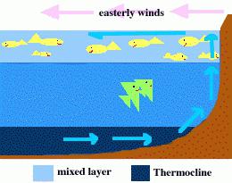
The processes of formation of the strongest warm current in the ocean in our century presumably look as follows. In ordinary weather conditions, when the El Niño phase has not yet occurred, warm surface ocean waters are transported and retained easterly winds— trade winds in the western zone of the tropical Pacific Ocean, where the so-called tropical warm pool (TTW) is formed. The depth of this warm layer of water reaches 100-200 meters. The formation of such a huge heat reservoir is the main necessary condition for the transition to the El Niño regime. Moreover, as a result of the surge of water, the ocean level off the coast of Indonesia is half a meter higher than the coast of South America. At the same time, the water surface temperature in the west in the tropical zone averages 29-30 °C, and in the east 22-24 °C. A slight cooling of the surface in the east is the result of upwelling, i.e., the rise of deep cold waters to the surface of the ocean when water is sucked in by trade winds. At the same time, the largest region of heat and stationary unstable equilibrium in the ocean-atmosphere system is formed above the TTB in the atmosphere (when all forces are balanced and the TTB is motionless).
For still unknown reasons, at intervals of 3-7 years, the trade winds weaken, the balance is upset, and the warm waters of the western basin rush east, creating one of the strongest warm currents in the World Ocean. Over a vast area in the eastern Pacific Ocean, there is a sharp increase in the temperature of the surface layer of the ocean. This is the onset of the El Niño phase. Its beginning is marked by a long onslaught of squally westerly winds. They replace the usual weak trade winds over the warm western part of the Pacific Ocean and prevent cold deep waters from rising to the surface. As a result, upwelling is blocked.
Although the processes themselves that develop during the El Niño phase are regional, their consequences are nonetheless global. El Niño is usually accompanied by environmental disasters: droughts, fires, heavy rains, causing flooding of vast areas of densely populated areas, which leads to the death of people and the destruction of livestock and crops in different regions of the Earth. El Niño has a significant impact on the global economy. According to American experts, in 1982-1983, economic damage from the consequences of El Niño amounted to $13 billion, and according to estimates from the world's leading insurance company Munich Re, damage from natural disasters in the first half of 1998 is estimated at $24 billion.
The warm western basin usually enters an opposite phase a year after an El Niño, when the eastern Pacific cools. Phases of warming and cooling alternate with a normal state, when heat accumulates in the western basin (WBT) and the state of stationary unstable equilibrium is restored.
According to many experts, the main cause of the current cataclysms is global warming climate as a result of the “greenhouse effect” due to technogenic development of the Earth and the accumulation of greenhouse gases in the atmosphere (water vapor, carbon dioxide, methane, nitrous oxide, ozone, chlorofluorocarbons).
Meteorological data on the temperature of the surface layer of the atmosphere, collected over the past hundred years, show that the climate on Earth has warmed by 0.5-0.6 °C. The steady rise in temperature was disrupted by a brief cold snap between 1940 and 1970, after which warming resumed.
Although the increase in temperature is consistent with the greenhouse effect hypothesis, there are other factors that influence warming (volcanic eruptions, ocean currents, etc.). It will be possible to establish the unambiguous cause of warming after the receipt of new data in the next 10-15 years. All models predict that warming will increase significantly in the coming decades. From this we can conclude that the frequency of the El Niño phenomenon and its intensity will increase.
Climate variations over the period of 3-7 years are determined by changes in vertical circulation in the ocean and atmosphere and ocean surface temperature. In other words, they change the intensity of heat and mass transfer between the ocean and the atmosphere. The ocean and atmosphere are open, nonequilibrium, nonlinear systems, between which there is a constant exchange of heat and moisture.
Such systems, by the way, are characterized by the self-organization of such formidable structures as tropical cyclones, which transport energy and moisture received from the ocean over long distances.
An assessment of the energy interaction between the ocean and the atmosphere allows us to come to the conclusion that the energy of El Niño can lead to disturbances in the entire atmosphere of the Earth, which leads to environmental disasters that have occurred in recent years.
In the future, as the famous Canadian scientist and climate change specialist Henry Hincheveld showed, “society needs to abandon the idea that climate is something unchanging. It is fluid, change will continue, and humanity needs to develop an infrastructure that allows it to be prepared to face the unexpected.”
Peruvian Current or Humboldt Current(Spanish: Corriente de Humboldt) - a cold ocean current in the southeastern part of the Pacific Ocean; flows from south to north from the shores of Antarctica along the western shores of and.
It is a wide, slow flow, consisting of the Peruvian Oceanic and Peruvian Coastal Currents, carrying relatively cold (from +15°C to +20°C) waters of temperate latitudes at speeds of up to 0.9 km/h; has a water consumption of 15-20 million l³/sec; gives rise to South Trade Wind Current.
Alexander von Humboldt
German encyclopedist, physicist, meteorologist, geographer and naturalist, baron Alexander von Humboldt(German Alexander Freiherr von Humboldt; 1769-1859), who traveled widely around Latin America, in 1812, discovered that a cold deep current moves from the polar regions towards the equator, cooling the air there.
In honor of this scientist, the Peruvian Current, which carries water along the South American coast, was also named the Humboldt Current.
Movement is life
 Continuous movement is one of the characteristic features waters of the World Ocean.
Large-scale masses of water that continuously move across the oceans are called ocean or sea currents. Each of the streams moves in a certain channel and direction, which is why they are sometimes called “rivers of the oceans”: the width of the largest currents can be several hundred km, and the length can reach more than one thousand km.
Every ocean has a clearly defined cycle of currents. Interestingly, they do not move in a straight line; the direction of the currents is determined by the following factors: constant winds (trade winds) blowing on both sides of the equator from east to west; outlines of continents; bottom relief; deflecting force of the Earth's rotation.
Sea currents form There are vicious circles in the oceans. The movement of water in these circles in the Northern Hemisphere occurs clockwise, and in the Southern Hemisphere - counterclockwise: the direction of the currents is determined by the rotation of the Earth around its axis.
Warm, cold
Depending on the water temperature, ocean currents are divided into warm And cold. Warm ones arise near the equator, they carry warm waters through cold waters located near the poles, and heat the air. Cold currents are directed from the polar regions to the equator; on the contrary, they lead to a decrease in air temperature.
The largest warm sea currents include: Gulf Stream (Atlantic Ocean), Brazilian (Atlantic Ocean), Kuroshio (Pacific Ocean), Caribbean (Atlantic Ocean), North and South Equatorial Currents (Atlantic, Pacific, Indian Oceans), Antilles (Atlantic Ocean) ).
The largest cold sea currents include: Peruvian (Pacific Ocean), Canary (Atlantic Ocean), Oyashio or Kuril (Pacific Ocean), East Greenland (Atlantic Ocean), Labrador (Atlantic Ocean) and California (Pacific Ocean).
Cold and warm currents come close to each other in some places, most often in temperate latitudes. As a result of the formation of an area of convergence of waters with different physical properties, vortices arise. These phenomena in the ocean influence air masses, formed over the ocean, and then manifest themselves in weather conditions on land at temperate latitudes.
The influence of currents on the life of the planet
The role of ocean currents in the life of our planet can hardly be overestimated, since the movement of water flows directly affects the Earth’s climate, weather, coastal flora and fauna, marine organisms. The ocean is often compared to a titanic thermal unit driven by the energy of the Sun. This machine creates a continuous exchange of water between the deep and surface layers of the ocean, affecting the life of marine life.
This process can be traced using the example of the Peruvian Current. Thanks to the rise of deep waters, which lift dissolved phosphorus and nitrogen upward, animal and plant plankton successfully develop on the ocean surface, serving as food for small fish. She, in turn, becomes a victim of larger fish, birds and many marine mammals, which, with such an abundance of food, settle here, making the region one of the most productive areas of the World Ocean. Water Characteristics of the Peruvian Current- very high biological activity; This is one of the main areas for fishing, the extraction of anchovies and tuna, as well as the collection of natural fertilizer - guano.
Peruvian Current: Interesting facts
- Global ocean currents move at speeds from 1 to 9 km/h.
- Sea currents play a huge role in the life of our planet. They contribute to the interlatitudinal distribution of heat, water masses and living organisms, and influence the circulation of the Earth’s atmosphere and climate. Studying the current regime is necessary for navigation and proper organization of fishing.
- The currents of the World Ocean are a kind of giant air conditioner that distributes cold and warm air around the globe.
- Currently according to international agreement from special ships, a bottle is thrown into the sea every day, in which a note is inserted indicating the exact location (latitude and longitude) and time (year, day and month). And the “traveler” sets off on a voyage, sometimes a very long one. For example, a bottle thrown in October 1820 in the southern part Atlantic Ocean, was found in August 1821 off the coast of the English Channel. Another, abandoned off the Cape Verde Islands (May 19, 1887), was caught off the Irish coast on March 17, 1890. One of the bottles made a particularly long journey in the Pacific Ocean: abandoned off south coast South America. She was found in a bay in New Zealand. Thus, in 1,271 days the bottle covered a distance of 20 thousand km, i.e. an average of 9 km per day.
- By mapping the paths taken by the bottles, experts are able to determine the trajectories and directions of currents. By noting the time when the bottle was thrown and found, they get an idea of the speed of the currents.
- In “drift bottles”, which are used to determine surface currents, add a little sand for ballast and insert a postcard or special form. The finder is asked to report the place and time of its discovery. Every year, the Woods Hole Oceanographic Institution (WHOI) releases 10–20 thousand “drifting” bottles into the sea off the east coast of the United States. As a rule, 10-11% of the cards included in them are usually returned. The information obtained about the drift was used to compile an atlas of surface ocean currents.
- Approaches the coast of Peru once every 12 years warm current, pushing back the cold Peruvian Current. It is called “El Niño” (Spanish El Niño - “Baby”), as it usually appears at Christmas. A sudden change in temperature leads to mass death all forms of marine organisms, which means that fish and fish-eating birds - guano producers - die from starvation.
At all times, the yellow press has increased its ratings due to various news of a mystical, catastrophic, provocative or revealing nature. However, in Lately More and more people are beginning to be frightened by various natural disasters, the ends of the world, etc. In this article we will talk about one natural phenomenon that sometimes borders on mysticism - the warm El Niño current. What is this? This question is often asked by people on various Internet forums. Let's try to answer it.
Natural phenomenon El Niño
In 1997-1998 One of the largest natural disasters associated with this phenomenon in the entire history of observations took place on our planet. This mysterious phenomenon caused a lot of noise and attracted close attention from the world media, and the encyclopedia will tell you its name for the phenomenon. In scientific terms, El Niño is a complex of changes in the chemical and thermobaric parameters of the atmosphere and ocean, taking on the character natural disaster. As you can see, this is a very difficult definition to understand, so let’s try to look at it through the eyes of an ordinary person. The reference literature says that El Niño is just a warm current that sometimes occurs off the coast of Peru, Ecuador and Chile. Scientists cannot explain the nature of the appearance of this current. The name of the phenomenon itself comes from Spanish and means "baby". El Niño got its name due to the fact that it appears only at the end of December and coincides with Catholic Christmas.

Normal situation
In order to understand the anomalous nature of this phenomenon, let us first consider the usual climate situation in this region of the planet. Everyone knows that mild weather in Western Europe The warm Gulf Stream determines the current, while in the Pacific Ocean of the Southern Hemisphere the tone is set by the cold Antarctic. The prevailing Atlantic winds here are the trade winds, which blow on the western South American coast, crossing the high Andes, leaving all the moisture on the eastern slopes. As a result West Side The mainland is a rocky desert where rain is extremely rare. However, when the trade winds pick up so much moisture that they can transport it across the Andes, they form a powerful surface current here, which causes a surge of water off the coast. The attention of specialists was attracted by the colossal biological activity of this region. Here, in a relatively small area, annual fish production exceeds the global total by 20%. This also leads to an increase in fish-eating birds in the region. And in places where they accumulate, a colossal mass of guano (dung) - a valuable fertilizer - is concentrated. In some places the thickness of its layers reaches 100 meters. These deposits became the object of industrial production and export.

Catastrophe
Now let's look at what happens when the warm El Niño current appears. In this case, the situation changes dramatically. An increase in temperature leads to mass death or loss of fish and, as a result, birds. Next comes the fall atmospheric pressure in the eastern part of the Pacific Ocean, clouds appear, trade winds subside, and the winds change their direction to the opposite. As a result, torrents of water fall on the western slopes of the Andes, floods, floods, and mudslides rage here. And on the opposite side of the Pacific Ocean - in Indonesia, Australia, New Guinea - a terrible drought begins, which leads to forest fires and destruction of agricultural plants. However, the El Niño phenomenon is not limited to this: “red tides”, which are caused by the growth of microscopic algae, begin to develop from the Chilean coast to California. It would seem that everything is clear, but the nature of the phenomenon is not completely clear. Thus, oceanographers consider the appearance of warm waters to be a consequence of a change in winds, and meteorologists explain the change in winds by the heating of waters. What kind of vicious circle is this? However, let's look at some things that climate scientists have missed.
Degassing El Niño scenario
What kind of phenomenon this is, geologists helped to figure it out. For ease of understanding, we will try to move away from specific scientific terms and tell everything in a generally accessible language. It turns out that El Niño forms in the ocean above one of the most active geological sections of the rift system (the rift earth's crust). Hydrogen is actively released from the depths of the planet, which, upon reaching the surface, forms a reaction with oxygen. As a result, heat arises, which warms the water. In addition, this also leads to the appearance of over the region, which also contributes to more intense heating of the ocean by solar radiation. Most likely, the role of the Sun is decisive in this process. All this leads to an increase in evaporation, a decrease in pressure, as a result of which a cyclone is formed.
Biological productivity
Why is there such high biological activity in this region? Scientists estimate that it corresponds to the heavily fertilized ponds in Asia and is more than 50 times higher than in other parts of the Pacific Ocean. Traditionally, this is usually explained by the wind driving warm waters from the coast - upwelling. As a result of this process, cold water, enriched with nutrients (nitrogen and phosphorus), rises from the depths. And when El Niño appears, upwelling is interrupted, as a result of which birds and fish die or migrate. It would seem that everything is clear and logical. However, here too, scientists do not say much. For example, the mechanism for rising water from the depths of the ocean slightly Scientists measure temperatures at various depths oriented perpendicular to the shore. Then graphs (isotherms) are constructed, comparing the level of coastal and deep waters, and the above-mentioned conclusions are drawn from this. However, measuring the temperature in coastal waters is incorrect, because it is known that their coldness is determined by the Peruvian Current. And the process of constructing isotherms across the coastline is incorrect, because the prevailing winds blow along it.
But the geological version easily fits into this scheme. It has long been known that the water column of this region has a very low oxygen content (the reason is a geological discontinuity) - lower than anywhere on the planet. And the upper layers (30 m), on the contrary, are abnormally rich in it due to the Peruvian Current. It is in this layer (above the rift zones) that unique conditions for the development of life are created. When the El Niño current appears, degassing in the region increases, and the thin surface layer is saturated with methane and hydrogen. This leads to the death of living beings, and not at all the lack of food supply.

Red tides
However, with the onset of an environmental disaster, life here does not stop. Single-celled algae - dinoflagellates - begin to actively reproduce in the water. Their red color is protection from solar ultraviolet radiation (we already mentioned that an ozone hole forms over the region). Thus, thanks to the abundance of microscopic algae, many marine organisms that act as ocean filters (oysters, etc.) become poisonous, and eating them leads to severe poisoning.

The model is confirmed
Let's consider an interesting fact that confirms the reality of the degassing version. American researcher D. Walker carried out work to analyze sections of this underwater ridge, as a result of which he came to the conclusion that during the years of El Niño, seismic activity sharply increased. But it has long been known that it is often accompanied by increased degassing of the subsoil. So, most likely, scientists simply confused cause and effect. It turns out that the changed direction of El Niño is a consequence, not the cause of subsequent events. This model is also supported by the fact that during these years the water literally boils with the release of gases.
La Niña
This is the name given to the final phase of El Niño, which results in a sharp cooling of the water. A natural explanation for this phenomenon is the destruction of the ozone layer over Antarctica and the Equator, which causes and leads to an influx cold water in the Peruvian Current, which cools El Niño.

Root cause in space
The media blames El Niño for the floods in South Korea, unprecedented frosts in Europe, droughts and fires in Indonesia, destruction of the ozone layer, etc. However, if you remember the fact that the mentioned current is just a consequence geological processes, occurring in the bowels of the Earth, then we should think about the root cause. And it is hidden in the influence on the core of the planet of the Moon, the Sun, the planets of our system, as well as others celestial bodies. So it’s useless to blame El Niño...
In the World Ocean, special phenomena (processes) are observed that can be considered anomalous. These phenomena extend over vast water areas and are of great ecological and geographical significance. Such anomalous phenomena covering the ocean and atmosphere are El Niño and La Niña. However, a distinction must be made between the El Niño current and the El Niño phenomenon.
El Niño current - a constant current, small on an oceanic scale, off the northwestern coast of South America. It can be traced from the Gulf of Panama area and follows south along the coasts of Colombia, Ecuador, Peru to about 5 0 S However, approximately once every 6 - 7 years (but it happens more or less often), the El Niño current spreads far to the south, sometimes to northern and even central Chile (up to 35-40 0 S). The warm waters of El Niño push the cold waters of the Peru-Chile Current and coastal upwelling into the open ocean. Ocean surface temperatures in the coastal zone of Ecuador and Peru rise to 21–23 0 C, and sometimes up to 25–29 0 C. The anomalous development of this warm current, which lasts almost six months - from December to May and which usually appears around Catholic Christmas, is called "El Niño" - from the Spanish "El Nico - the baby (Christ)." It was first noticed in 1726.
This purely oceanological process has tangible and often catastrophic environmental consequences on land. Due to the sharp warming of water in the coastal zone (by 8-14 0 C), the amount of oxygen and, accordingly, the biomass of cold-loving species of phyto- and zooplankton, the main food of anchovies and other commercial fish of the Peruvian region, significantly decreases. A huge number of fish either die or disappear from this water area. Peruvian anchovy catches fall 10 times in such years. After the fish, the birds that feed on them also disappear. As a result of this natural disaster, South American fishermen are going bankrupt. In previous years, the abnormal development of El Niño led to famine in several countries on the Pacific coast of South America. . In addition, during the passage of El Niño weather conditions in Ecuador, Peru and northern Chile are deteriorating sharply, where powerful downpours occur, leading to catastrophic floods, mudflows and soil erosion on the western slopes of the Andes.
However, the consequences of the anomalous development of the El Niño current are felt only on the Pacific coast of South America.
The main culprit for the increasing frequency of weather anomalies in recent years, which have covered almost all continents, is called El Niño/La Niña phenomenon, manifested in a significant change in the temperature of the upper layer of water in the eastern tropical Pacific Ocean, which causes intense turbulent heat and moisture exchange between the ocean and the atmosphere.
Currently, the term "El Niño" is used in relation to situations where abnormally warm surface waters occupy not only the coastal region near South America, but also most of the tropical zone Pacific Ocean up to the 180th meridian.
Under normal weather conditions, when the El Niño phase has not yet arrived, warm surface ocean waters are held by easterly winds - trade winds - in the western zone of the tropical Pacific Ocean, where the so-called tropical warm pool (TTB) is formed. The depth of this warm layer of water reaches 100-200 meters, and it is the formation of such a large heat reservoir that is the main and necessary condition for the transition to the El Niño phenomenon. At this time, the water surface temperature in the west of the ocean in the tropical zone is 29-30°, while in the east it is 22-24°C. This difference in temperature is explained by the rise of cold deep waters to the surface of the ocean near west coast South America. At the same time, in the equatorial part of the Pacific Ocean, a water area with a huge reserve of heat is formed and equilibrium is observed in the ocean-atmosphere system. This is a situation of normal balance.
Approximately once every 3-7 years, the balance is disrupted, and the warm waters of the western Pacific Ocean move east, and over a huge area of water in the equatorial eastern part of the ocean, a sharp increase in the temperature of the surface layer of water occurs. The El Niño phase begins, the beginning of which is marked by sudden heavy westerly winds (Fig. 22). They reverse the usual weak trade winds over the warm western Pacific and prevent cold deep waters off the west coast of South America from rising to the surface. Related El Niño atmospheric phenomena were called the Southern Oscillation (ENSO - El Niño - Southern Oscillation) because they were first observed in the Southern Hemisphere. Due to the warm water surface, intense convective rise of air is observed in the eastern part of the Pacific Ocean, and not in the western part, as usual. As a result, the area heavy rains shifts from the western regions of the Pacific Ocean to the eastern ones. Rain and hurricanes hit Central and South America.
Rice. 22. Normal conditions and the onset phase of El Niño
Over the past 25 years, there have been five active El Niño cycles: 1982-83, 1986-87, 1991-1993, 1994-95 and 1997-98.
The mechanism of development of the La Niña phenomenon (in Spanish La Niça - “girl”) - the “antipode” of El Niño is somewhat different. The La Niña phenomenon manifests itself as a decrease in surface water temperature below the climate norm in the eastern equatorial zone of the Pacific Ocean. Installation here is unusual cold weather. During the formation of La Niña, easterly winds from the west coast of the Americas increase significantly. Winds shift the warm water zone (WWZ), and the “tongue” of cold waters stretches for 5000 kilometers in exactly the place (Ecuador - Samoa Islands) where during El Niño there should be a belt of warm waters. This belt of warm waters moves to the western Pacific Ocean, causing powerful monsoon rains in Indochina, India and Australia. At the same time, the countries of the Caribbean and the United States suffer from droughts, dry winds and tornadoes.
La Niña cycles occurred in 1984-85, 1988-89 and 1995-96.
Although the atmospheric processes that develop during El Niño or La Niña mostly operate in tropical latitudes, their consequences are felt throughout the planet and are accompanied by environmental disasters: hurricanes and rainstorms, droughts and fires.
El Niño occurs on average once every three to four years, La Niña - once every six to seven years. Both phenomena bring with them an increased number of hurricanes, but during La Niña there are three to four times more storms than during El Niño.
The occurrence of El Niño or La Niña can be predicted if:
1. Near the equator in the eastern part of the Pacific Ocean, an area of warmer water than usual (El Niño phenomenon) or colder water (La Niña phenomenon) forms.
2. The atmospheric pressure trend between the port of Darwin (Australia) and the island of Tahiti (Pacific Ocean) is compared. During El Niño, pressure will be low in Tahiti and high in Darwin. During La Niña it is the other way around.
Research has established that the El Niño phenomenon is not only simple coordinated fluctuations in surface pressure and ocean water temperature. El Niño and La Niña are the most pronounced manifestations of interannual climate variability on a global scale. These phenomena represent large-scale changes in ocean temperature, precipitation, atmospheric circulation, and vertical air movements over the tropical Pacific Ocean and lead to abnormal weather conditions around the globe.
During El Niño years in the tropics, precipitation increases over areas east of the central Pacific Ocean and decreases over northern Australia, Indonesia and the Philippines. In December-February, above-normal precipitation is observed along the coast of Ecuador, in northwestern Peru, over southern Brazil, central Argentina and over equatorial, eastern Africa, during June-August in the western United States and over central Chile.
El Niño is also responsible for large-scale air temperature anomalies around the world.
During El Niño years, energy transfer into the troposphere of tropical and temperate latitudes increases. This is manifested in an increase in thermal contrasts between tropical and polar latitudes, and intensification of cyclonic and anticyclonic activity in temperate latitudes.
During El Niño years:
1. The Honolulu and Asian anticyclones are weakened;
2. The summer depression over southern Eurasia is filled, which is the main reason for the weakening of the monsoon over India;
3. The winter Aleutian and Icelandic lows are more developed than usual.
During La Niña years, precipitation increases over the western equatorial Pacific Ocean, Indonesia, and the Philippines and is almost completely absent in the eastern part of the ocean. More precipitation falls in northern South America, in South Africa and south-eastern Australia. Drier than normal conditions are observed along the coast of Ecuador, northwestern Peru and equatorial eastern Africa. There are large-scale temperature excursions around the world, with the largest number of areas experiencing abnormally cool conditions.
Over the past decade, great strides have been made in the comprehensive study of the El Niño phenomenon. This phenomenon does not depend on solar activity, but is associated with features in the planetary interaction of the ocean and atmosphere. A connection has been established between El Niño and the Southern Oscillation (El Niño-Southern Oscillation - ENSO) of surface atmospheric pressure in southern latitudes. This change in atmospheric pressure leads to significant changes in the trade wind system and monsoon winds and, accordingly, surface ocean currents.
The El Niño phenomenon is increasingly affecting the global economy. So, this phenomenon of 1982-83. provoked terrible rainfalls in the countries of South America, caused enormous losses, and the economies of many countries were paralyzed. The effects of El Niño were felt by half of the world's population.
The strongest El Niño of 1997-1998 was the strongest during the entire observation period. It caused the most powerful hurricane in the history of meteorological observations, sweeping over the countries of South and Central America. Hurricane winds and downpours swept away hundreds of houses, entire areas were flooded, and vegetation was destroyed. In Peru, in the Atacama Desert, where rains generally occur once every ten years, a huge lake with an area of tens of square kilometers has formed. Unusually warm weather was recorded in South Africa, southern Mozambique, Madagascar, and unprecedented drought reigned in Indonesia and the Philippines, leading to forest fires. India experienced virtually no normal monsoon rains, while arid Somalia received significantly above normal rainfall. The total damage from the disaster amounted to about 50 billion dollars.
El Niño 1997-1998 significantly affected the average global air temperature of the Earth: it exceeded normal by 0.44°C. In the same year, 1998, the highest average annual air temperature was recorded on Earth for all years of instrumental observations.
The collected data indicate the regular occurrence of El Niño with an interval ranging from 4 to 12 years. The duration of El Niño itself varies from 6–8 months to 3 years, most often it is 1–1.5 years. This great variability makes it difficult to predict the phenomenon.
The influence of the climatic phenomena El Niño and La Niña, and therefore the number of unfavorable weather conditions on the planet, according to climate specialists, will increase. Therefore, humanity must closely monitor and study these climate phenomena.
Thu, 06/13/2013 - 20:25
The circulation of the Pacific Ocean waters consists of two anticyclonic gyres. The Northern Gyre includes currents: the North Equatorial, Mindanao and Kuro-sio, the North Pacific and California. The Southern Gyre consists of currents: part of the Antarctic Circumpolar, Peruvian (Cromwell), South Equatorial and East Australian. These gyres are separated by the Equatorial (inter-trade wind) countercurrent. Its border with the South Equatorial Current is an equatorial front that blocks the warm water of the Equatorial Countercurrent from reaching the coasts of Ecuador and Peru. Upwelling is developed here, ensuring high productivity of coastal waters. In the case of El Nino, a warm anomaly occurs that moves east
Natural disasters are not uncommon on our planet. They happen both on land and at sea. The mechanisms of development of catastrophic phenomena are so intricate that it takes scientists years to come closer to understanding the complex set of cause-and-effect relationships in the “atmosphere-hydrosphere-Earth” system.
One of the destructive natural phenomena, accompanied by numerous human casualties and colossal material losses - El Niño. Translated from Spanish, El Niño means “baby boy,” and it is so named because it often occurs around Christmas. This “baby” brings with it a real disaster: off the coasts of Ecuador and Peru, the water temperature rises sharply, by 7...12°C, fish disappear and birds die, and prolonged heavy rains begin. Legends about such phenomena have been preserved among the Indians of local tribes since the times when these lands were not conquered by the Spaniards, and Peruvian archaeologists have established that in ancient times local residents, to protect themselves from catastrophic heavy rains, they built houses not with flat roofs, as they are now, but with gable roofs.
Although El Niño is usually referred to as only oceanic effects, in fact this phenomenon is closely related to meteorological processes called the Southern Oscillation, which is, figuratively speaking, an atmospheric “swing” the size of an ocean. In addition, modern researchers of the nature of the Earth have also managed to identify the geophysical component of this amazing phenomenon: it turns out that mechanical and thermal vibrations of the atmosphere and ocean jointly rock our planet, which also affects the intensity and frequency of environmental disasters.
Ocean waters flow and... sometimes stop
In the southern tropical part of the Pacific Ocean in normal years (under average climatic conditions) there is a huge circulation with water moving counterclockwise. The eastern part of the gyre is represented by the cold Peruvian Current, heading north along the coasts of Ecuador and Peru. Near Galapagos Islands under the influence of trade winds, it turns to the west, turning into the South Equatorial Current, which carries relatively cold waters in this direction along the equator. Along the entire border of its contact in the equator region with the warm inter-trade countercurrent, an equatorial front is formed, preventing the flow of warm countercurrent waters to the coast of Latin America.
Thanks to this system of water circulation along the coast of Peru, in the zone of the Peruvian Current, a huge area of rise of relatively cold deep waters, well fertilized with mineral compounds, is formed - the Peruvian upwelling. Naturally, he provides high level biological productivity in the area. This picture was called “La Niña” (translated from Spanish as “baby girl”). This “sister” El Niño is quite harmless.
In anomalous climatic conditions years, La Niña transforms into El Niño: the cold Peruvian Current, paradoxically, practically stops, thereby “blocking” the rise of deep cold waters in the upwelling zone, and as a result, the productivity of coastal waters sharply decreases. The ocean surface temperature throughout the region rises to 21...23°C, and sometimes to 25...29°C. The temperature contrast at the border of the South Equatorial Current with the warm inter-trade current or disappears altogether - the equatorial front is washed away, and the warm waters of the Equatorial Countercurrent spread unhindered towards the coast of Latin America.
The intensity, magnitude and duration of El Niño can vary significantly. So, for example, in 1982...1983, during the period of the most intense El Niño over the 130-year period of observations, this phenomenon began in September 1982 and lasted until August 1983.
Other materials in the section

General information about tsunamis. Most often, a tsunami occurs as a result of an underwater earthquake. For the strongest earthquakes, about 1% of the earthquake energy is converted into tsunami energy. Interestingly, tsunami energy increases in proportion to the square of the wave height.
The length of the tsunami front is approximately equal to the length of the earthquake source, and the wavelength is approximately equal to the width of the source. The height at the source does not exceed the height of the rock uplift, i.e. 10 -2 -10 m for earthquake energy of about 10 14 -10 20 J. Due to the low height and long wavelength (10-100 km), the tsunami remains practically in the ocean unnoticeable. The height of the tsunami increases significantly when approaching the shore, i.e., in shallow water. Usually the height of the water hill does not exceed 60-70 m.

In 1868, the expedition of the Swedish polar explorer Nils Nordenskiöld on the ship “Sofia” lifted dark stones from the bottom of the Kara Sea, which turned out to be ferromanganese nodules. Then the British oceanographic expedition on the corvette Challenger (1872-1876) discovered similar nodules on the bottom of the Atlantic in the Canary Islands area. The attention of geologists was attracted by the fact that, in addition to iron and manganese, a certain amount of non-ferrous metals was noticeable in them. Subsequently, underwater photography showed that the bottom sometimes resembles a cobblestone street: it is completely covered with nodules measuring 4-5 cm. The nodules protrude from the silt or form a layer up to half a meter thick in the upper part of the soil. The amount of ore reaches 200 kg/m2.

According to “authoritative sources”, 2012 was declared by the ancient Mayans as the year of the end of the world. Soon after the "extreme" New Year's holidays a friend of my son decided to get additional information on this issue and found a chronological tablet on the Internet: a list of dates for apocalypses predicted by anyone. As it turned out, rare year missing from it. The voluptuous anticipation of one’s own death is one of mankind’s favorite pastimes. The devouring of the Sun by the mythical wolf Fenrir or mythical dog Garm, the transformation of the Sun into a supernova, the accomplishment of the Last Sin, the collision of the Earth with an unknown planet, nuclear war, global warming, global glaciation, simultaneous eruption of all volcanoes, simultaneous reset of all computers, simultaneous burning of all transformers, AIDS pandemic, swine, chicken or cat flu. Some of these dire predictions have nothing to do with science, others are partly based on scientific facts. There are also those that have a chance to turn out to be a reality, because there is no escape, our planet is really a speck of dust in infinite universe, a toy of enormous cosmic forces.

...In the developments of the Hydroenergoproject (under the leadership of M.M. Davydov), water intake from the Ob and its transfer to the Central Asian republics were assumed in the area of the village. Belogorye. Here it was planned to build a dam 78 m high with a power plant with a capacity of 5.6 million kW. The reservoir formed by the dam with a surface area of more than 250 km² spread along the Irtysh and Tobol to the watershed. Beyond the watershed, the transfer route ran along the southern slope of the Turgai Gate along the beds of modern and ancient rivers to the Aral Sea. From there it was supposed to reach the Caspian Sea along the Sarykamysh basin and Uzboya. The total length of the canal from Belogorye to the Caspian Sea was 4,000 km, of which about 1,800 km were natural waters and reservoirs. The water transfer was planned to be carried out in three stages: in the first - 25 km³, in the second - 60 km³, in the third - 75-100 km³, increasing the volume of water intake from the Ob...

Despite advances in the synthesis of artificial precious stones, including diamonds, the demand for natural stones is not falling. Crystals, born millions of years ago in the depths of the earth, become the pride of museums and private collections, they are used as banking assets... And most importantly, as in ancient times, diamonds remain the most desirable and expensive women's jewelry. But modern “treasure hunters” hope not only for luck: they strive to penetrate the very mystery of the origin of crystalline carbon in order to get their hands on a reliable guide in their difficult search...
One day my teacher Zbigniew Bartoszynski, a professor at the Department of Mineralogy at Lviv University, said with a hint of irritation: “Soon diamonds will be found behind the stove at home.” It was about opening in 1980.

Why do earthquakes occur? The generally accepted explanation is offered by the theory of plate tectonics. According to this theory, the lithosphere, the fragile solid shell of the Earth, is non-monolithic. It is divided into plates, which move due to the movement of the plastic hard shell located below - the asthenosphere. And that, in turn, moves due to convective movements in the planet’s mantle: hot matter rises up, and cooled matter sinks. Why this does not happen on other planets is unclear, but for Earth the theory of plate tectonics has been considered proven since the sixties of the 20th century. It was discovered that the long hills on the ocean floor - the so-called mid-ocean ridges - are composed of the youngest rocks, and their slopes are constantly moving away from each other.

...So, kimberlites and lamproites allowed us to look into the upper mantle of the Earth, to depths of 150-200 km. It turned out that at such depths, as on the surface, the composition of the Earth is heterogeneous. Variations in the composition of the mantle are caused, on the one hand, by repeated melting of magmatic rocks. rocks(depleted mantle), on the other hand, its enrichment with deep fluids and crustal material (enriched mantle). These processes are quite complex and depend on many factors: the composition of the introduced fluids and sediments, the degree of melting of the mantle material, etc. As a rule, they are superimposed on one another, causing complex multi-stage transformations. And the intervals between these stages can be hundreds of millions of years...

After the tragic events of December 26, 2004 in Southeast Asia, almost the entire population of our planet started talking about the tsunami. After the water wave, an information tsunami hit you and me.
It was enough to look at the headlines of newspapers and magazines, listen to announcements of television and radio programs, or turn to the Internet. For example, these. "Intrigues leap year" "The tsunami is the Earth's revenge for the flourishing depravity in the countries of Southeast Asia." "What's going on with the weather?" "What's happened? How unique is this? "Hurricane and flooding in Europe." "An unprecedented thaw in Moscow." Let us add from the author - both in Kharkov and in Ukraine as a whole there was the same thaw in January 2005. “Earthquake in Donbass.” “The Orange Revolution and the tsunami are links in the same chain.” “Unprecedented snowfalls in Africa, America...” "The tsunami is the work of the Jews." The tsunami is “the result of secret tests of atomic weapons by the United States, Israel and India.”

...Modern marine geomorphologists, developing the concept of the shelf, have replenished the stock of geographical terms with one more, detailing previous ideas about the underwater “stone shelves” of the continents. Within the shelves, they distinguish the coastal zone - a section of the seabed limited on the land side by the line of the maximum, annually repeating surge of the surf flow, and on the sea side by a depth corresponding to 1/3 of the length of the largest storm wave in a given place. It is to this depth that active waves in the open sea penetrate. If we take it to be 60 m, then the area of the coastal zone of the World Ocean turns out to be equal to 15 million km 2, or 10% of the earth's land surface.
In recent years, some scientists have defined the coastal zone as a contact zone of mechanical interaction of moving masses of water and bottom material with each other and with a stationary bottom. ..

Earthquakes that occur quietly and slowly are fraught with danger. They can generate tsunamis or strong tremors that shake the earth's crust.
A giant landslide caused by a quiet earthquake can cause a tsunami hundreds of meters high.
In November 2000, the largest earthquake in the last ten years occurred on the island of Hawaii. At magnitude 5.7, about 2 thousand cubic meters. km of the southern slope of the Kilauea volcano tilted towards the ocean. Some of the progress has occurred in a place where hundreds of tourists stop every day.
How did such a significant event go unnoticed? It turns out that shaking is not inherent in all earthquakes. What happened on Kilauea was first identified as a manifestation of a silent earthquake - a powerful tectonic movement that became known to science only a few years ago. My colleagues at the USGS Hawaiian Volcano Observatory, who were conducting observations of volcanic activity, detected the shaking. Noticing that the southern slope of Kilauea had moved 10 cm along the tectonic fault, I found that the mass movement lasted about 36 hours - a snail's pace for a normal earthquake. Typically, the opposite walls of a fault rise in a matter of seconds, generating seismic waves that cause a rumble and shaking of the surface.